 |
Geographic north |  |
| The gnomons of horizontal sundials in the northern hemisphere point to geographic north, the North Pole, but how accurate is the layout of the 1913 Ingleside Terraces Sundial?
(In the accompanying google map aerial view of the IT sundial, the gnomon appears to point to the right, but that is due to camera not being directly overhead.) | |
| The IT sundial is surrounded by four hearts, the apices of which point in the cardinal directions, north, east, south, and west, a "compass rose" design. The centers of the hearts originally had plantings that formed the directions N, E, S, W historic sundial photo. The plantings have been replaced by letters in this photo.
A vertical line placed using Photoshop starting at the north apex goes through the center of the sundial and also intersects the south apex, showing that the placement of the IT sundial is accurate within a fraction of a degree. The four classical columns are in the ordinal directions:
|

The horizontal line between the west and east heart apices goes through the center of the sundial. The base of the gnomon is in an east-west line with the 6 A.M. and 6 P.M. Roman numerals (and also with sunrise and sunset at the vernal and autumnal equinoxes). The base of the gnomon is approximately 5/9 of the distance between the center of the sundial and the inner aspect of the dial with the Roman numerals, corresponding to this sundial being located at approximately 5/9 of the distance between the north pole and the equator. |
 |
Egyptian pyramids from 2500 B.C. are also aligned in north-south, east-west directions. |
| A compass points to magnetic north, not to geographic north, but there are several ways to determine geographic north.
Put up a vertical pole and place stones at the end of its shadow multiple times throughout the day. The location with the shortest shadow, which occurs at solar noon when the sun is farthest north and highest in the sky, points to geographic north. Or from a starting point, place markers at sunrise and sunset and connect the markers with a line. The line will be east-west and a line at right angles to the east-west line will be north-south. |
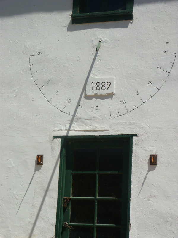
This is a vertical sundial on an historic farmhouse in Smugglers Cove, Santa Cruz Island. The photo was taken on 8/9/2006 at 11:52 A.M. Longitude is -119.545 degrees, latitude 34.023. Sundial time is read as approximately 10:45 A.M. NOAA correction for this location and date is 1 hr. 4 minutes, which results in a clock time of 11:49 A.M., so the sundial reading could be off by three minutes, assuming the camera time was correct. | 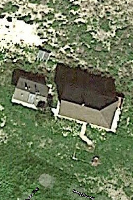
In the photo of the vertical sundial, the gnomon is located above approximately 12:20 on the sundial, instead of 12:00 as would be expected for a vertical sundial. As the above photo of this farmhouse on Google maps shows, the farmhouse is facing about 197 degrees SSW, which would displace the shadow of the gnomon to the left, so rotating the numbers to the left improves the accuracy of the sundial. The spacing of the numbers is not correct, but in a remote location such as this in the 1800's, a sundial that was correct once a day, at noon, would most likely serve its purpose. |

Here is an easy way to determine solar noon. Many cities have streets laid out in a north-south, east-west grid, similar to that of the Egyptian pyramids 4500 years ago. In San Francisco, only a few areas have a N>S-E>W grid. Jules Street is oriented geographic N>S. This photo, taken on July 22 at 1:16 P.M., shows the shadow of a telephone pole parallel to the curb, which correctly indicates that solar noon is at 1:16 P.M. on that date. NOAA Solar noon on a sundial |

Miramar Avenue, 0.87 miles length, is apparently the longest geographic N>S street in San Francisco. |

